
| |
| home |
| projects |
| contact me |
| links |
NUCLEAR ISLAND?
artit
The East Anglian coast has been eroding for thousands of years - most of Dunwich (once one of the most important towns in East Anglia), part of Aldeburgh, and most recently Orford Ness lighthouse - have all been lost to the sea. It’s the same story of erosion and loss all along this sandy and fragile coastline.
Climate change will make things a lot worse, bringing unpredictable and continuous rises in sea levels - perhaps one or even two meters by the end of this century, with much more in future years - and the likelihood of more frequent and stronger storms in coming decades.
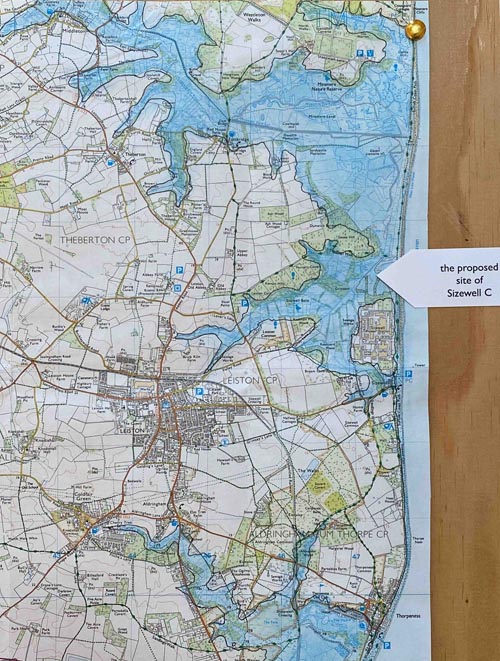
The 1953 storm surge which devastated the east coast caused flooding to land up to 5.6 metres above sea level. This map highlights the 5 meter contour line to illustrate the ‘wateriness’ and vulnerability of the Suffolk coast and its hinterland. Is this the place to build one of the biggest infrastructure projects in Europe, and to site two nuclear reactors and all their associated waste for over one hundred years?
The proposed initial height of Sizewell C’s sea defences is over 14 meters. But that is only their initial height: EDF acknowledge that they will need to reinforced and increased in height in future years to keep the site safe until at least the mid 2100s. And because the site for Sizewell C is too small for all that is planned, its sea defences will be much closer to the sea than those of Sizewell A & B, decimating rare shingle habitats.
Click on Walking at the Edge to continue your tour
Or go straight to individual artworks:
C Beyond introduction - NO NO NO (hopes for our children) - The Elephant in the Room - Jayne Ivimey's Bird by Bird
The Sizewell C White Elephant - Sizewell C needs YOU - Out of Order - Battered Seafood - Nuclear island?
Walking at the Edge - C Views - Sizewell Scud - #sizewellcnot4me
return to flyintheface homepage